
North Saskatchewan River
At Edmonton House, the York Factory Express joined the Saskatchewan Brigades, who were carrying their furs down the North Saskatchewan River to Hudson Bay. I had to learn about every river these men rowed or sailed on, and this is some of what I learned about the North Saskatchewan!
The North Saskatchewan, “which begins as a rivulet trickling from the toe of the Saskatchewan Glacier in the Rocky Mountains, is, by the time it reaches Edmonton House, a powerful river that, in springtime, foams through a steep-banked valley that lies almost 200 feet below the level of the surround parklands. It usually carried the HBC men downriver with ease, but the journey may have been a claustrophobic experience for some, as they ploughed down a coffee-with-milk coloured river between looming banks of mud or clay of a similar shade. Even the grass was brown at this time of year.”
You can order my books, The HBC Brigades, and The York Factory Express, through Amazon if you wish — at https://amazon.com/author/nancymargueriteanderson
Canadians can also order my books here: https://ronsdalepress.com/products/york-factory-express-the
My new book, Working Title: Three Journeys North to the Arctic Sea, will be published in January 2027.
I had a lot of help from a book titled Reading the River: A Traveller’s Companion to the North Saskatchewan River, by Myrna Kostash, with Duane Burton [Coteau Books, 2005]. The North Saskatchewan begins hundreds of miles west of Edmonton, in the Saskatchewan Glacier. Gathering up the waters of various tributaries such as the Brazeau, Nordegg, Ram, Clearwater — and east of Edmonton, the Sturgeon, Vermillion, and Battle River, it flows through modern day-towns of Saskatchewan River Crossing, Rocky Mountain House, Drayton Valley west of Edmonton, and Fort Saskatchewan and Battleford/North Battleford to the east of the city.
Other books helped me too, for example, Majorie Wilkins Campbell The Saskatchewan. “The North Saskatchewan quickly disproves the theory that all glacial water is green,” she says. “Pale putty is the colour of the North Saskatchewan in the mountains, and often lower down on the prairies, when it is not a cascade of white lace, misty as a spider’s web…The Saskatchewan up near the icefields is heavy and opaque with the limestone it is continually washing away from the rocks along its course.”
The upper river has some interesting natural features: for example an extensive braided river channel area known as the “Graveyard Flats,” at the river’s confluence with the Alexandra River. There are impressive river terraces downstream of the Saskatchewan River Crossing, and some volcanic ash layers near the Howse River confluence, which are evidence of volcanic activity 5,000 years ago. The river valley is thought to have been occupied by First Nations people for at least 10,000 years. The river itself is 800 miles long, and has a drainage area of 47,413 square miles. It flows southeast through Banff National Park, after which it wanders around for a while through the foothills. At Rocky Mountain House it abruptly turns north for 100 kms., before turning to the east for Edmonton House.
The westernmost fur trade post on the North Saskatchewan River is Rocky Mountain House. It began its life in 1799 as two fur trade posts, when the North West Company and the HBC established rival posts 211 miles upriver from modern-day Edmonton (Edmonton House was not at that spot at the time these two posts were built). The NWC post was Rocky Mountain House, the HBC’s Acton House. They were built almost next door to each other on the river’s flood-plain, at the confluence of the Clearwater River. It was from Rocky Mountain House that, in 1807, David Thompson began his journey across the Rocky Mountains into Columbia District, and with him at that time was Joseph Beaulieu, Jaco Finlay, and a whole host of other Canadien and Métis men who established enormous families west of the Rocky Mountains. West of Rocky Mountain House is Abraham Lake, the Kootenae Plains; and “The Forks,” which for David Thompson was the junction of the North Saskatchewan and Howse Rivers. Thompson and his men went up the Howse River, and descended the Blaeberry River on the west side of the Rockies, and were soon on the banks of the Columbia River. Not an easy journey by any means, but they did it!
Rocky Mountain House still existed after 1821 when the North West Company and the HBC merged, and the Rocky Mountain House brigades under Louis Leblanc are occasionally mentioned as arriving at Edmonton House in the various York Factory Express Journals. So, not only were the men from Lesser Slave Lake, Fort Assiniboine, and Jasper’s House part of the outgoing Saskatchewan Brigades, so too were the men from Rocky Mountain House. In fact I believe one year not so long ago, that Edmonton had a re-enactment of the Rocky Mountain House brigades arriving at the replica Fort Edmonton, situated in the river valley below the place where the actual fort stood. (I was following someone on that brigade on Twitter at the time). Whether they came all the way down the river from Rocky Mountain House I do not know — but, honestly, I wish they still did this re-enactment!
In her book The Saskatchewan, Marjorie Wilkins Campbell outlined the full river and its flow: “Below Rocky Mountain House the river flows on and down through the deep channel it is still cutting, past the city of Edmonton; by Fort Pitt, once an important pemmican-distributing post in the fur trade days, on to the Battlefords, where it gathers in the historical Battle River of Indian war fame, and so to Prince Albert and its meeting with its greatest tributary, the vast South Saskatchewan. The Forks, as this great meeting of the waters has been called, was once the site of the first white man’s house built up the river. No one knows for how long before that year, 1749, Indians met there in the spring, or parted in the autumn to go on their lonely trapping expeditions. The river doesn’t tell all it knows.”
A modern-day kayaker who paddled the river from its source to Edmonton, and beyond, says that the upper parts of the river was “a mix of easy straight sections alternating with many very fast and wild curves often containing standing waves as high as 2 1/2 feet.” The standing waves were, of course, rapids. In Abraham Lake he found a sheet of glass, a lake surrounded by gravel bars. As he neared Nordegg, “the river’s course narrowed and became either flat on the straight-aways or fast and furious around corners cutting through very high hills.” Near Rocky Mountain House he found whirlpools that spanned the entire river. He does not mention the canyon on that part of the river, but here is what another author has to say of the banks of the river between Devon and Edmonton, and upriver from that too:
And I think that wilderness is there in Edmonton or Devon, as you look at the way the river has entrenched the valley, and you see sheer sides of layer upon layer of thousands of years of sediment exposed, because it is often too steep for the vegetation to take hold, and you know that stuck in there in those mud rock banks are almost certainly arrowheads, and below, in the lower layers, the fossilized bones of bison, from before even arrowheads had ever been made. And of course it’s real wilderness along the marvellous road from Rocky Mountain House into the mountains, and there is that tremendous rushing waterfall whose name I forget vaulting over a high fault-line of one of the river-heads, and that always reminds me that the river there is really young and exuberant and heedless, but nonetheless has grandfathers — or is it the gods? — of the mountains watching over its birth.
Reading the River, page 85.
That is a very nice way to look at the upper part of the North Saskatchewan River. Devon, by the way, is twenty five miles southwest of Edmonton and it is not part of Drayton Valley, which is even further west. So I would presume, from above, the the deep river valley runs east from Devon, through and past Edmonton.
East of Edmonton House, the North Saskatchewan is a shallow river, varying from a meter to three meters deep! The York Factory Express men went down the river with the freshets in May, and came up the river again in September when the water was low. And in some years, when the river was extremely low because of drought, it was difficult even to descend. This, from James Douglas’s journal, 1835:
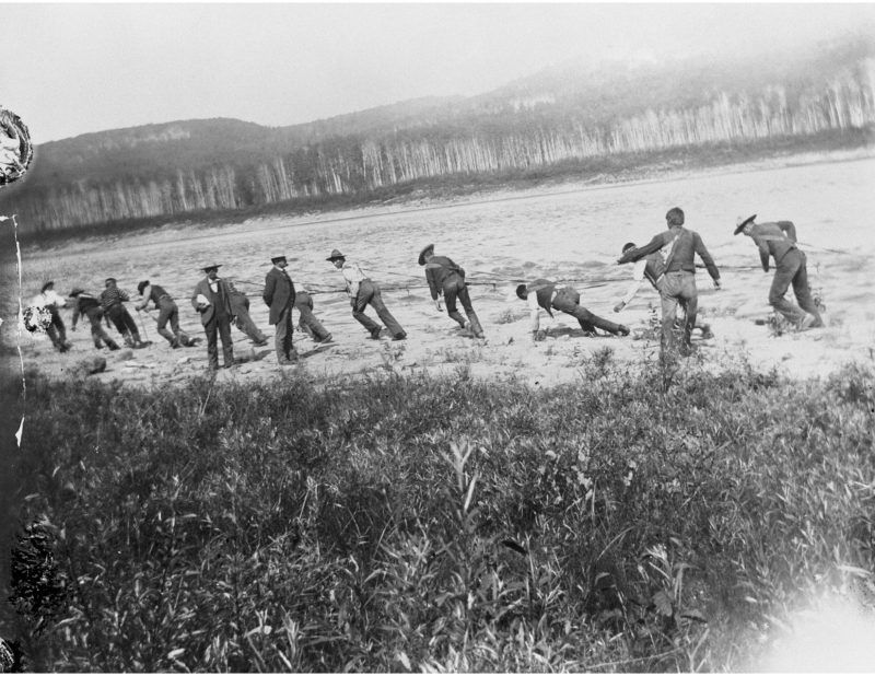
The river is so very low that our progress is continually interrupted by the numerous banks of gravel and scattered rocks which are concealed from view by a small depth of untransparent fluid. The boats are incessantly taking ground on the one hand, or striking heavily on the other, and the crews on these occasions have no other way of clearing these obstacles but by leaping out and dragging them [the boats] into deeper water, which is certainly not an agreeable pastime on a cold morning with ice forming all around them.
Edmonton has a long history on the North Saskatchewan River. In about 1795, the NWC built a post at the forks of the Sturgeon River and North Saskatchewan, at modern-day Fort Saskatchewan. (Fort Saskatchewan takes its name from a military fort, not a fur trade one). They called this new post Fort Augustus, and William Tomison of the HBC built Fort Edmonton at the same place. In 1801 both posts moved upriver to the later location of the Rossdale power plant in modern-day Edmonton, where there was a ford. In 1810 both were moved downstream to the mouth of White Earth/White Mud Creek, near modern-day Pakan (Victoria Settlement). Then in 1812-1813 both moved back upriver to the Rossdale Flats once again. This fort became known as Edmonton House when the two companies merged in 1821, and in 1826 it was the largest fort on the prairies. After a flood in 1830, Edmonton House was moved to the height of land, where the government buildings located behind the Parliament Buildings now stand. Chief Factor John Rowand was in charge of Edmonton House from 1823 to his death in 1853.
The banks of the river at Edmonton are 150 to 200 feet above the level of the river. I’ve been told that going down the North Saskatchewan River in a boat is like passing through a tunnel. But once the boats reached White Mud Creek, on the northernmost bend of the river, the bluffs fall away and the river banks opened up to the fine parklands that surrounded this deep, brown valley. That kayaker I mentioned previously said this of his journey downriver past this point:
The next few days carried me through scenery that can only be found on the prairies. Willow thickets brimming with many species of bird and animals including elk, deer, beaver, black bear, wild dogs once domesticated, coyote and others whose ID I am not sure of. Of large birds of prey, I saw many many bald eagles, red tailed and other hawks, turkey vultures and possibly a few falcons. Of waterfowl I saw many species of duck, cormorants, blue herons, pelicans, terns, and Canada geese.
“Along the Banks of the Saskatchewan: A Kayak Trip Down the Saskatchewan River,” by Robert Pruden, December 15, 2008, on http://www.paddlinglight.com/ I hadn’t noticed the writer’s name before now.
The beaver kept this kayaker awake at night, slapping their tails on the water to chase him away. And yes, there are beaver here: that’s what brought the fur traders up the river, after all. On big rivers like the North Saskatchewan they build their houses on the side of the river, but they do not build dams.
“For the most part, the North Saskatchewan flows through forest and park land,” Marjorie Wilkins Campbell writes. As you are journeying down the river, the landscapes changes from the rocks of the mountains to brown silt at the beginning of the prairies, to fine black sucking mud later on in the Saskatchewan River estuary. But we’re not there yet…
Northeast of Myram, Alberta, and downriver from Edmonton House, is the old Fort de l’Isle, where LaMothe killed James King (see link below). Please note: There was another Fort de l’Isle in Saskatchewan, on Pine Island, which we will talk about later in this blogpost. This Fort de l’Isle is an archaeological site that represents the remains of the three old forts that stood here in the years between 1799 and 1801. The XY Company was here, as was the NWC, and the HBC. There is approximately 43 hectares of land on an island in the North Saskatchewan River, where all three forts are represented by cellar depressions, chimney rock piles, and assorted cultural materials such as buried wood fragments, animal bones, and metal fragments. The original post “Island Fort” was established in 1799 by Alexander McKenzie (nephew of Sir Alexander Mackenzie) of the XY Company (New North West Company). The fort was built to compete with two downriver forts, Buckingham House and Fort George, however by 1801, the NWC post Fort George had moved north to the island, and the Hudson’s Bay Company also built there. After the murder that occurred on or near the island — see link below — both the Hudson’s Bay Company and the North West Company abandoned the place and instead built the paired forts of Fort Vermilion and Paint Earth House on the Saskatchewan River.
The story of James King’s death is told here: https://nancymargueriteanderson.com/james-king/
The old locations of Fort George & Buckingham House are the next places of interest on this river. In 1792, Buckingham House was established by Peter Fidler and William Tomison, and Fort George was built by Angus Shaw of the NWC. (A tidbit here: the voyageurs called Angus Shaw “le Chat” [the cat], and his children “kittens.”) Large herds of bison and deer roamed here, and there were also Moose in the Elk Point area nearby. Fort George was abandoned when Shaw built Fort de l’Isle (above) in 1801, and by 1809 it was in ruins. But this was an excellent place for a fur trade post, in a fertile but slender stretch of land wedged between the boreal forests to the north, and the southern grasslands. The Fort George & Buckingham House Provincial Historic site is located just outside Elk Point, Alberta, and is called the Fort George & Buckingham House Provincial Historic Site.
Fort Pitt was 217 miles downriver from Edmonton House, and Carlton House another 214 miles downriver from Fort Pitt. This provisioning post was built in 1830, on a flat above a bluff but below the high old bank of the North Saskatchewan River. It stood on the north side of the river, on a large bend in the river. The fort itself was built within 100 paces of the river bank, and was half the size of Carlton House. The fort was located where the territories of the Cree, the Assiniboine, and the Blackfoot merged. The stockades were 15 feet high and 15 feet long on every side. The North Saskatchewan River was deep and rapid here, and free from sandbars for once — tracking upriver here was a real chore for the incoming York Factory Express men. Harold Innes, author of The Fur Trade in Canada, says:
This establishment furnishes the largest quantity of pemmican and dry meat for the posts more distant from the plains. The buffalo are seldom far from Fort Pitt, and often whilst there is a famine at Carlton and Edmonton, the people of the “Little Fort,” as it is called, are feasting on fresh meat every day.” The source of this quote is The Northwest by Land, by Viscount Milton and WB. Cheadle.
Pine Island was sometimes called Fort de l’Isle, but it is not the same island as the one already mentioned, on which Fort de l’Isle stood. This Pine Island consisted of a heavily forested 38 hectare island in the North Saskatchewan River, approximately midway between the town of North Battleford and the modern-day Alberta border. In 1786, as many as five trading concerns operated on Pine Island: the North West Company; Peter Pangman, who was a partner in Gregor, MacLeod & Company from Montreal; Donald MacKay; and an individual named Champagne. By 1787 McKay and Champagne had departed and Gregor, McLeod had merged with the North West Company. So, at the time of the story that follows, only the NWC Pine Island Fort, and the HBC’s Manchester House remained on the island. In 1793, the Gros Ventres [the Fall Indians, or Big Bellies] attacked the post and took it, stripping the employees of trade goods and personal possessions. The NWC abandoned the island, and the HBC abandoned their fort, which burned down a year later. Everyone remembered its history: and the HBC men of the 1830’s called it Fort Brule [Burnt].
The Battle River flows into the North Saskatchewan where the towns of Battleford and North Battleford now stand. Explorer Anthony Henday, who spent time here in the 1850s, called it the Chacutenah, which name was supposedly translated to Battle River. Peter Fidler was the first man who used that name for the river. The river is a major tributary of the North Saskatchewan, and is 350 miles long with drainage area of 11,700 square miles. It begins in Battle Lake. For the York Factory Express men, however, there were no stories attached to this river, so if there was a story, it was lost over time. (However, the Eagle Hills is here, or very near here, and there are battle stories attached to that place!)
Eagle Hills is the location of John Cole’s Fort Montagne d’Aigle, and, yes, there was a battle here! You can find the story here: https://nancymargueriteanderson.com/john-cole/
What the fur traders all called “The Elbow” is in the area of the Borden Bridge, where the flow of the river changes from generally southeasterly to a north easterly direction. For most of the people who live in modern-day Saskatchewan, the Elbow refers to the bend on the South Saskatchewan River — but in the days of the York Factory Express, this bend was also called the Elbow.
Carlton House was the next major HBC fort on the North Saskatchewan River. It was situated in a place where the trees ended and the plains began, where there were gently undulating hills with groves of trees rather than never ending forest. The post was built a quarter of a mile back from the river. This was not the only location of Carlton House: the first was below the junction of the North and South Saskatchewan, on the Saskatchewan River. In 1804 it was re-established on the South Saskatchewan, but six years later rebuilt next to a rival NWC post on the North Saskatchewan, at La Montee, a shallow ford. At this time the NWC post and that of the HBC had a common palisade. The NWC left, but the HBC remained there, and is still there. I’ve been told it is an excellent place to visit!
Campement des Femmes was a place on the north bank of the North Saskatchewan River, where the Cree left their families in safely while they were out hunting. It was just upriver from the Lacolle Rapids, which the fur traders called Cole’s Rapids.
Cole’s Rapids. This is Lacolle Falls or rapids, a boulder strewn stretch of water just upriver from the confluence of the North Saskatchewan and the Saskatchewan Rivers. Fortunately, coming upriver, the shores were wide and sandy, which allowed the HBC men good footing as they tracked the heavily loaded boats upriver. But coming downriver it was different: in 1847 Thomas Lowe came down when the water was especially low:
Thurs. 3rd. Rainy. Came to Cole’s Rapids before breakfast, but having broken two boats, put ashore to breakfast and get them repaired. In course of the day 5 more boats were broken, one of them having gone to pieces, the crew saving themselves by springing into a boat which was passing. Most of the cargo was picked up and distributed amongst the Brigade…Encamped half way down the Rapids.
They continued their work the next day and were able to leave Cole’s Rapids by 2 pm. But 8 boats were broken more or less, and one was entirely lost. However: “A short distance below these Rapids, the Southern Branch falls into the Saskatchewan, and as there happened to be a good flush of water in it, we made a good distance before camping.”
They were now in the Saskatchewan River, and that will be another blogpost at some point in time. There is lots of interesting and historical spots in the Saskatchewan River, perhaps more than in the North. It certainly was a busier river in the early days, with many more fur trading posts than the North Saskatchewan had. When this Saskatchewan River post is written, I will include it here: https://nancymargueriteanderson.com/saskatchewan-river/
Copyright, Nancy Marguerite Anderson, 2020. All rights reserved.